

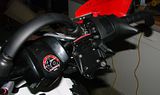
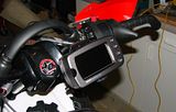
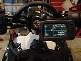
Just recently found the 'waterproof' info in my manual so I decided I needed to start using it on the sled. Pics are clickable.


sandmanmike1
New member
Is there a way to hook up a tether to the GPS in case it pops loose. I had one on mine and needed it twice. Something to look into. Looks good.
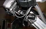
The bracket clamp has a tamper resistant screw to tighten once the unit is clamped in. I will look into a lanyard for it though, in case the bracket breaks, thanks.
crewchief,
I just got a tomtom gps for the car and really like your garmin. Where did you purchase and cost for the setup. Can you use it for the car too?
I just got a tomtom gps for the car and really like your garmin. Where did you purchase and cost for the setup. Can you use it for the car too?
The 2610 is dis-continued, I've had mine for 3 years. You can still find them on Ebay I think. The 2620 is hard drive based so avoid it. It has auto routing but doesn't have text to speech so you only get 'turn right 300 feet' instead of the name of the road. The whole of US/Canada map data will fit on a 2GB card(not supplied). I got enough map info onto the stock 128Mb card to make a trip from Detroit to Dallas, but not very far off the expected route. Speaker is built into the power cord and it doesn't take batteries at all. weighs around 1 lb(Hefty sucker). The Ram mount and Garmin Craddle with power lead cost me $86 CAN from gpscity.ca
If you have anymore questions, let me know. I guess alot of the Europe motorcycle guys love these cause they're around 150-200 on Ebay, and work well enough in the outdoors. I was kind of looking for a new unit for the sled untill I noticed the waterproof rating.
If you have anymore questions, let me know. I guess alot of the Europe motorcycle guys love these cause they're around 150-200 on Ebay, and work well enough in the outdoors. I was kind of looking for a new unit for the sled untill I noticed the waterproof rating.
sandmanmike1 said:Is there a way to hook up a tether to the GPS in case it pops loose. I had one on mine and needed it twice. Something to look into. Looks good.
Thankfully I followed your tether advice before the TY Ride in Muni. The sled spent a couple minutes with the rubber side up after a dis-agreement with a rock. I looked for the GPS once while it was upside down and didn't see it in the cradle so I said a small prayer that the lanyard held. When I got the rubber side down finally, the GPS was hanging from the handguard the lanyard was hooked over. No damage to the Garmin and it fired right up like nothing happened.
I really liked how the GPS worked for my first trip with it, it had alot of the National Forest roads in the map info so it worked pretty good that way. Would like to one day follow trail 7 or Haywire south and then follow the GPS back to see what we can find.
I have a Lowrance 3500 C GPS which has a 5" color display. I have mapped Many trails in Minnesota, UP, Lower Michigan and some in Indiana. I can add stop signs, warning signs, bridge, fuel, restaurants ect, icons on the display. Last night I brought the unit into the house hooked up to 12 connection and input all of the trail numbers on the trails. I saved the trails onto a SD card also for transfer to another display. Not sure if Garman and Lowrance communicat with each other but I am willing to share information. I too installed the unit on the handlebars. I will not have another machine without a gps. I see these as being an option in the future, with trail map cards being sold and advertised on.
You may want to add your file here, it's where I got my Ontario stuff. Don't think it's compatible with my Garmin.
http://www.gpssledmaps.com/
http://www.gpssledmaps.com/
I am going to take some pic's of the unit and try to figure out how to post them.