Urgent - Winter Weather Message
National Weather Service Marquette Mi
1008 Pm Est Sat Nov 5 2005
...significant Snowfall Possible Over East Central Upper
Michigan...
.low Pressure Developing Over The Central Plains Will Strengthen
As It Tracks Across Northern Lower Michigan On Sunday Morning And
Into Ontario During The Afternoon. Rain Will Overspread Central
Upper Michigan Overnight And Then Mix With And Change Over To
Snow Sunday Morning As Cold Air Filters Into The Area. There Is
The Potential For Significant Snowfall Accumulations Over The
East Half Of Upper Michigan On Sunday Inland From The Great Lakes
Shores...if Warmer Air From The Southeast Does Not Delay The
Change To Snow. The Passage Of Cold Air Across The Warmer Waters
Of Lake Superior Will Also Develop Lake Effect Snow Showers Sunday
Afternoon And Evening Before The Arrival Of High Pressure Ends
This Snow Early Monday Morning.
Miz006-007-013-014-085-061115-
/o.con.kmqt.ws.a.0001.051106t1100z-051106t2300z/
Alger-luce-delta-southern Schoolcraft-northern Schoolcraft-
Including The Cities Of...munising...newberry...escanaba...
Gladstone...manistique...seney
1008 Pm Est Sat Nov 5 2005
...winter Storm Watch Remains In Effect From 6 Am Est Sunday
Through Sunday Afternoon...
Expect Rain To Mix With Or Change To A Wet...heavy Snow Over
The Watch Area Sunday Morning. By Sunday Evening...as Much
As 5 To Locally 8 Inches May Accumulate Inland From The Great
Lakes Shores. The Possible Accumulation Of Slushy Snow On Roads In
The Watch Area May Make Travel Hazardous Through Most Of The Day.
Strong North To Northwest Winds With Gusts As High As 30 To 40
Mph Will Increase The Hazard For High Profile Vehicles.
!")
National Weather Service Marquette Mi
1008 Pm Est Sat Nov 5 2005
...significant Snowfall Possible Over East Central Upper
Michigan...
.low Pressure Developing Over The Central Plains Will Strengthen
As It Tracks Across Northern Lower Michigan On Sunday Morning And
Into Ontario During The Afternoon. Rain Will Overspread Central
Upper Michigan Overnight And Then Mix With And Change Over To
Snow Sunday Morning As Cold Air Filters Into The Area. There Is
The Potential For Significant Snowfall Accumulations Over The
East Half Of Upper Michigan On Sunday Inland From The Great Lakes
Shores...if Warmer Air From The Southeast Does Not Delay The
Change To Snow. The Passage Of Cold Air Across The Warmer Waters
Of Lake Superior Will Also Develop Lake Effect Snow Showers Sunday
Afternoon And Evening Before The Arrival Of High Pressure Ends
This Snow Early Monday Morning.
Miz006-007-013-014-085-061115-
/o.con.kmqt.ws.a.0001.051106t1100z-051106t2300z/
Alger-luce-delta-southern Schoolcraft-northern Schoolcraft-
Including The Cities Of...munising...newberry...escanaba...
Gladstone...manistique...seney
1008 Pm Est Sat Nov 5 2005
...winter Storm Watch Remains In Effect From 6 Am Est Sunday
Through Sunday Afternoon...
Expect Rain To Mix With Or Change To A Wet...heavy Snow Over
The Watch Area Sunday Morning. By Sunday Evening...as Much
As 5 To Locally 8 Inches May Accumulate Inland From The Great
Lakes Shores. The Possible Accumulation Of Slushy Snow On Roads In
The Watch Area May Make Travel Hazardous Through Most Of The Day.
Strong North To Northwest Winds With Gusts As High As 30 To 40
Mph Will Increase The Hazard For High Profile Vehicles.
Last edited:
Bakemono
New member
Id read on HCS that Michigan had gotten some snow. It didnt look like much from the pics that were posted, but its a start!
Cap'n
Cap'n
It just missed me here it is just east of me right now all the web cams have snow on the ground to the east.
vipertripplexxx
New member
pics fresh from JD's
Here's whatcha got near grand marais.
Here's whatcha got near grand marais.

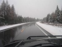
Nothing to get excited about...just 5-6 inches of wet sloppy snow. I was driving home from Kinross to Marquette yesterday, and the snow started around Raco, and spread as far west as Shingleton. It was raining before the day ended, so most is probably gone by now.
I snapped the following photo along M-28 just past Hulbert...a bit blurry, but what do you expect for 65 m.p.h.
I snapped the following photo along M-28 just past Hulbert...a bit blurry, but what do you expect for 65 m.p.h.